Opinions on NC roads around Little Switzerland?
 07-27-2015, 02:32 PM
#1
Burning Brakes

Thread Starter
I mapped out what looks like a very fun hard driving route in the mountains of Western North Carolina near the Blue Ridge Pkwy. It is a twisty loop kind of running roughly from Marion to Little Switzerland to Pleasant Gardens (just using those as convenient point fixes on the map). Highway 226A is known as The Diamondback and Highway 80 is known as The Devil's Whip. Both seem to be covered on sites for motorcycle enthusiasts.
If you have driven these, do you have any input on the following questions?
1) How's traffic? Cars, motorcycles, bicyclists, hikers?
2) How's the frequency of law enforcement? Radar/laser more prevalent?
3) Is one direction better than the other for car driving?
4) Any good restaurants I should look out for?
Thanks!
UPDATED: Please see posts 21 and 22 for a route map, tips, and personal opinions after the drive.
Last edited by CaryKen; 08-20-2015 at 11:20 PM. Reason: Added update notification
 07-27-2015, 07:25 PM
#2
Burning Brakes

I drove part of it about 2 months ago. We originally were going to do the whole loop and decided to take a detour and check out Mt Mitchell. We ate lunch there at the restaurant near the top of the mountain. I was using the GPS on my phone and got lost because I didnt have service, forgot a turn and pretty much had to wing it when we never made it to Little Switzerland.
Anyway, the part we rode on was pretty fun. Just have to watch out for bicyclist. traffic wasnt bad, but kept getting behind the casual prius driver which killed the experience.
Anyway, the part we rode on was pretty fun. Just have to watch out for bicyclist. traffic wasnt bad, but kept getting behind the casual prius driver which killed the experience.

 07-27-2015, 08:07 PM
#3
Pro


I mapped out what looks like a very fun hard driving route in the mountains of Western North Carolina near the Blue Ridge Pkwy. It is a twisty loop kind of running roughly from Marion to Little Switzerland to Pleasant Gardens (just using those as convenient point fixes on the map). Highway 226A is known as The Diamondback and Highway 80 is known as The Devil's Whip. Both seem to be covered on sites for motorcycle enthusiasts.
If you have driven these, do you have any input on the following questions?
1) How's traffic? Cars, motorcycles, bicyclists, hikers?
2) How's the frequency of law enforcement? Radar/laser more prevalent?
3) Is one direction better than the other for car driving?
4) Any good restaurants I should look out for?
Thanks!
07-27-2015, 08:27 PM
#4
Burning Brakes
These guys just went that route yesterday. about 12 or so Vettes, I think. Here's a link to the facebook page with an answer to your question.
https://www.facebook.com/groups/vict...ecorvetteclub/
https://www.facebook.com/groups/vict...ecorvetteclub/
07-27-2015, 08:28 PM
#5
Instructor

Hi CaryKen,
A bunch of us from Victory Lane Corvette Club rode Diamondback up to Little Switzerland this past Sunday. We have done it several times. We've also ran Devil's Whip. Both are great Corvette roads to run.
We didn't see any LEO on Diamondback Sunday.
Having done it both 'up' to Little Switzerland and 'down' from there, my personal preference is running it 'up'... you get to accelerate up through many curves rather than braking down through them. Both ways are fun though.
Traffic was light when we went, around 11-1130am Sunday.
More cars than motorcycles, I think I saw a bike or two...
We ate lunch at the Little Switzerland Inn. They were very accommodating for our large group (26 people)
We then took the Parkway to Blowing Rock, which was another great ride.
Enjoy your trip!
07-27-2015, 09:21 PM
#6
Pro
I went with VLCC also. It's a fun ride, worth the drive. My radar detector never alerted me of any law enforcement , didn't see any hikers, cyclist etc. there were a few motorcycles. Just keep in mind 226A does have driveways, businesses and other things along the route unlike tail of the dragon. It's just a curvy country rd, not 11 miles of switchbacks. I personally like it better than the dragon. Hope you enjoy your trip.
07-28-2015, 07:17 PM
#8
Race Director

I'm one of the RCC group and yes we have made that run a few times. I also have family up there so I have been there very often. LEO's aren't really anymore prevalent than other areas around there. It's not near as bad as the Dragon @ Deals Gap and not quite as challenging or as long either, but It is fun and some nice driving.
07-28-2015, 09:04 PM
#9


Devil's whip is fun. Watch out for oncoming traffic due to a few blind corners. I went on a week day and there was little traffic. No cops. I went around 1pm. If you want you can take blue ridge all the way to Grandfather Mountain and take 221 to blowing Rock.
07-28-2015, 11:09 PM
#10
Burning Brakes
Member Since: Jul 2001
Location: Youngsville North Carolina
Posts: 1,131
Likes: 0
Received 4 Likes
on
4 Posts

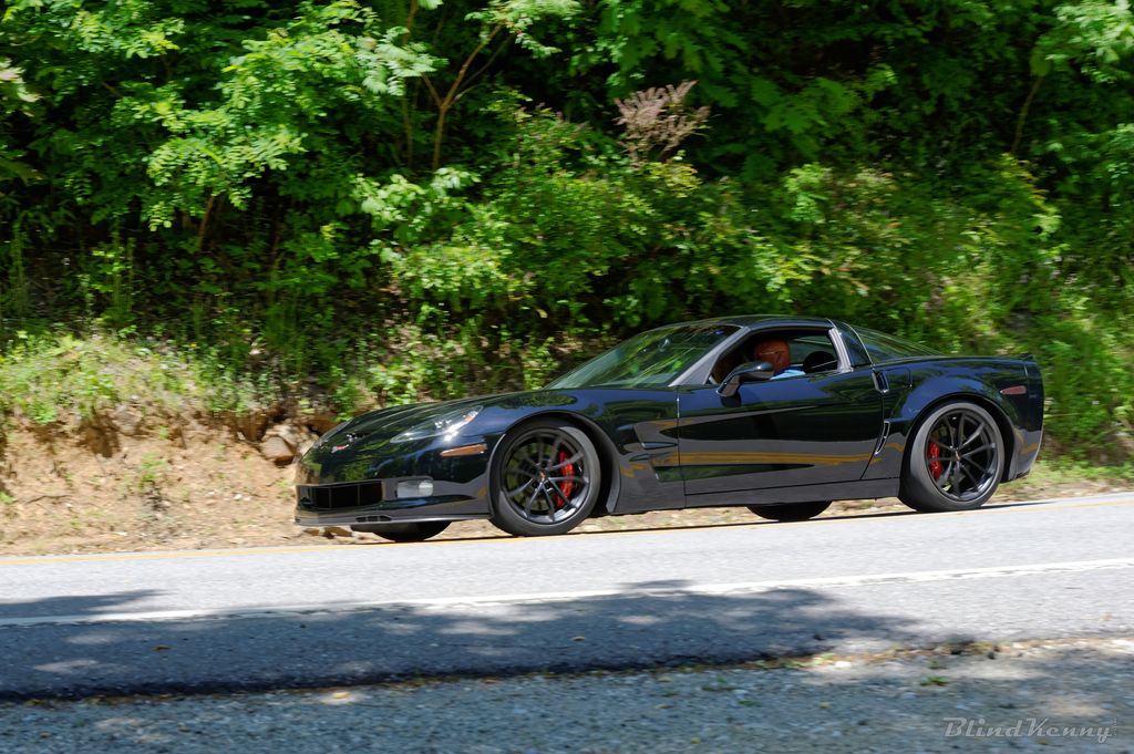
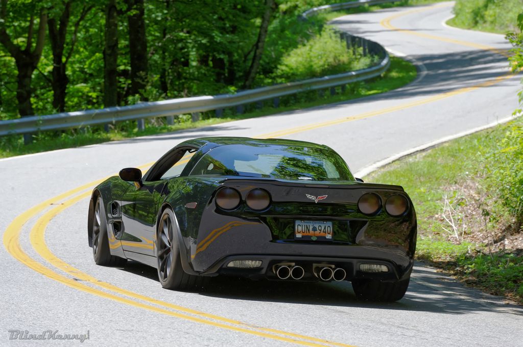
The Devil's Whip (80) was the highlight for me on a similar route. It was so good that when I got to the parkway I just turned around and went down and back up again.
Blind Kenny will take your picture if there on a weekend. They are very close to the Parkway.
It is a little further of a road trip but VA16 "Back of the Dragon" is excellent as well. http://backofthedragon.com/
Blind Kenny will take your picture if there on a weekend. They are very close to the Parkway.
It is a little further of a road trip but VA16 "Back of the Dragon" is excellent as well. http://backofthedragon.com/
07-30-2015, 08:13 PM
#11
Team Owner


Member Since: Dec 2010
Location: Hillsborough NC
Posts: 21,065
Received 745 Likes
on
429 Posts
NC Events Coordinator

We should get together sometime and drive some of these:
North Carolina Motorcycle Roads
I can personally vouch for SR-66. wish it was longer.
North Carolina Motorcycle Roads
I can personally vouch for SR-66. wish it was longer.
08-05-2015, 11:14 PM
#12
Burning Brakes
Thread Starter
Thanks for the suggestions and opinions, gang!
I have mapped out a vomit-inducing loop starting and ending in Morganton, which is a convenient flag point for me coming from the Raleigh triangle area. 402 miles and a Mapquest estimate of 10 hours actual driving time. This is easily adjustable for people coming from the Charlotte area. People coming from Atlanta or South Carolina can just pick it up at the bottom of the loop.
My goals were to minimize the amount of time spent on the Blue Ridge Parkway and Highway 40 while maximizing the number of twisty-turnies I could find on good quality major roads.
This link should load the full route in Mapquest in your browser:
http://mapq.st/1DrXTfp
Here is the itinerary spelled out:
LOOP TOTAL = 402 mi and 10 hrs
I plan to try the drive later this month and I'll report back. Unfortunately I have a 2014, so no PDR installed.

I have mapped out a vomit-inducing loop starting and ending in Morganton, which is a convenient flag point for me coming from the Raleigh triangle area. 402 miles and a Mapquest estimate of 10 hours actual driving time. This is easily adjustable for people coming from the Charlotte area. People coming from Atlanta or South Carolina can just pick it up at the bottom of the loop.
My goals were to minimize the amount of time spent on the Blue Ridge Parkway and Highway 40 while maximizing the number of twisty-turnies I could find on good quality major roads.
This link should load the full route in Mapquest in your browser:
http://mapq.st/1DrXTfp
Here is the itinerary spelled out:
- 181 N � Morganton towards Jonas Ridge
- Left onto 183 towards Linville Falls
- Left onto Blue Ridge Pkwy toward Asheville
- Left (S) onto 226
- Right (W/N) onto 226A to Little Switzerland
- Blue Ridge Pkwy S/W towards Asheville
- Left onto 80 S towards Pleasant Gardens
- Right onto 70 SW toward Old Fort
- Right onto 40 W toward Asheville
- Right onto 240 N into Asheville
- Broadway St. N out of town
- 251 N (Old Marshall Hwy) toward Marshall
- 25/70 N/W toward Hot Springs
- 209 S toward Bluff, Trust, Luck across 40 to Waynesville
- S/W on 74 (Great Smoky Mts. Expy) towards Sylva
- Left on Asheville Hwy into Sylva
- Left on E Main St (107) towards Cullowhee
- Continue on 107 to Tuckasegee
- Left on 281 S toward Lake Toxaway
- Left on 64 E toward Rosman
- Left on 215 N (Parkway Rd) toward Canton
- Right on 276 S (Cruso Rd) toward Brevard/Penrose
- 64 E towards Hendersonville
- Continue 64 (Chimney Rock Rd) to Bat Cave
- Jog left and take 9 N to Old Fort and Hwy 40
- Connect with 40 E back to Morganton
LOOP TOTAL = 402 mi and 10 hrs
I plan to try the drive later this month and I'll report back. Unfortunately I have a 2014, so no PDR installed.
08-07-2015, 10:32 AM
#13
Thanks for the suggestions and opinions, gang!
I have mapped out a vomit-inducing loop starting and ending in Morganton, which is a convenient flag point for me coming from the Raleigh triangle area. 402 miles and a Mapquest estimate of 10 hours actual driving time. This is easily adjustable for people coming from the Charlotte area. People coming from Atlanta or South Carolina can just pick it up at the bottom of the loop.
My goals were to minimize the amount of time spent on the Blue Ridge Parkway and Highway 40 while maximizing the number of twisty-turnies I could find on good quality major roads.
This link should load the full route in Mapquest in your browser:
http://mapq.st/1DrXTfp
Here is the itinerary spelled out:
LOOP TOTAL = 402 mi and 10 hrs
I plan to try the drive later this month and I'll report back. Unfortunately I have a 2014, so no PDR installed.
I have mapped out a vomit-inducing loop starting and ending in Morganton, which is a convenient flag point for me coming from the Raleigh triangle area. 402 miles and a Mapquest estimate of 10 hours actual driving time. This is easily adjustable for people coming from the Charlotte area. People coming from Atlanta or South Carolina can just pick it up at the bottom of the loop.
My goals were to minimize the amount of time spent on the Blue Ridge Parkway and Highway 40 while maximizing the number of twisty-turnies I could find on good quality major roads.
This link should load the full route in Mapquest in your browser:
http://mapq.st/1DrXTfp
Here is the itinerary spelled out:
- 181 N � Morganton towards Jonas Ridge
- Left onto 183 towards Linville Falls
- Left onto Blue Ridge Pkwy toward Asheville
- Left (S) onto 226
- Right (W/N) onto 226A to Little Switzerland
- Blue Ridge Pkwy S/W towards Asheville
- Left onto 80 S towards Pleasant Gardens
- Right onto 70 SW toward Old Fort
- Right onto 40 W toward Asheville
- Right onto 240 N into Asheville
- Broadway St. N out of town
- 251 N (Old Marshall Hwy) toward Marshall
- 25/70 N/W toward Hot Springs
- 209 S toward Bluff, Trust, Luck across 40 to Waynesville
- S/W on 74 (Great Smoky Mts. Expy) towards Sylva
- Left on Asheville Hwy into Sylva
- Left on E Main St (107) towards Cullowhee
- Continue on 107 to Tuckasegee
- Left on 281 S toward Lake Toxaway
- Left on 64 E toward Rosman
- Left on 215 N (Parkway Rd) toward Canton
- Right on 276 S (Cruso Rd) toward Brevard/Penrose
- 64 E towards Hendersonville
- Continue 64 (Chimney Rock Rd) to Bat Cave
- Jog left and take 9 N to Old Fort and Hwy 40
- Connect with 40 E back to Morganton
LOOP TOTAL = 402 mi and 10 hrs
I plan to try the drive later this month and I'll report back. Unfortunately I have a 2014, so no PDR installed.
If you did go that route then on your way home out of Lake Lure you would get back on 70 in Old Fort, let it carry you into Marion and then follow (Hankins road, Lake James Road, South Mtn Institute road, 126, Fish Hatchery Road, back to 181 and then down into Morganton.
Or if you wanted to do that in the beginning, then take Fish Hatchery road on the left coming out of Morganton on 181, travel it around to Marion and take 221 N up to Linville Falls which puts you back on your original loop.
Must have taken a long time to put that together, good job! Either way, great ride!
 08-07-2015, 12:11 PM
#14
Burning Brakes
Thread Starter
Great suggestion, thanks! I'll keep that in my back pocket in case I have the extra time and endurance on the way back. Very much appreciate the extra input.
--Ken
--Ken
Just as an FYI......IF you had a little more time and wanted another small detour off of I-40 then you could come back and go across the North side of Lake James. Depending on the time and day (they are open Thur-Sun) there is a nice Marina (Bear Creek Marina) with a restaurant/bar by the water that would make a good stopping place.
If you did go that route then on your way home out of Lake Lure you would get back on 70 in Old Fort, let it carry you into Marion and then follow (Hankins road, Lake James Road, South Mtn Institute road, 126, Fish Hatchery Road, back to 181 and then down into Morganton.
Or if you wanted to do that in the beginning, then take Fish Hatchery road on the left coming out of Morganton on 181, travel it around to Marion and take 221 N up to Linville Falls which puts you back on your original loop.
08-07-2015, 03:30 PM
#15
Smokin' BBQ Member
Opinions? Everyone has one. Any of this group that gives suggestions are generally road-proven. Keep it between the white lines and give a nod to law enforcement. Enjoy the cooler temps!
08-11-2015, 07:48 PM
#16
How about starting at 221 in Blowing Rock?
08-15-2015, 01:51 PM
#18
Burning Brakes
Thread Starter
Thanks for the tip.
08-18-2015, 08:12 PM
#19
Smokin' BBQ Member
Hobart Cove/Green River Cove Roads outside of Saluda (Off I-26 below Asheville) are quite a challenge to a) keep your car on the road and b) stay out of the way of old school buses packed with whitewater rafting fanatics.
No guardrails in most sections. If you go off into the woods/mountains/river, the Forest Service will find you come the first windy day in October.
No guardrails in most sections. If you go off into the woods/mountains/river, the Forest Service will find you come the first windy day in October.
08-18-2015, 10:56 PM
#20
Burning Brakes
I really love 226a. My friends and I skipped it last year on our annual mountain trip because we were trying to get to the Dragon before it rained. Hopefully I can make a run up this October with the Z.
Driving up 226a in my G8.
Another one of my favorite roads, SR215 which runs south from Waynesville, NC and up to the Blue Ridge Parkway. I have only driven it going downhill and it's a blast.
https://www.google.com/maps/dir/35.1...a=!4m2!4m1!3e0
Driving up 226a in my G8.
Another one of my favorite roads, SR215 which runs south from Waynesville, NC and up to the Blue Ridge Parkway. I have only driven it going downhill and it's a blast.
https://www.google.com/maps/dir/35.1...a=!4m2!4m1!3e0